 آردا، دنیای تالکین سایت طرفداران تالکین در ایران. جایی برای گفتگو در مورد ارباب حلقه ها و دیگر آثار تالکین به زبان فارسی
The Tolkien Estate Limited – used with kind permission©
این مقاله به فارسی نیز وجود دارد. در اینجا آن را مطالعه نمایید.
-Written by Mohammad Reza Kamali
-Edited by Allacin Morimizu
In part 1 and part 2 of these series of articles, I have tried to show step by step the similarities between Middle-earth and our own green earth. I think these similarities are so precise, it is practically impossible for them to be just a simple coincidence. Nevertheless, it is still possible to consider these similarities as some kind of accident or even as a “deliberate making of similarities.” This is a belief I have encountered many times, and those who believe it have their reasons. One is they believe this research has never provided any “real evidence” for these similarities. What constitutes “real evidence” for these individuals is only if Professor Tolkien mentioned these similarities in his notes, letters, or interviews. No such statement has yet been found. Does that therefore mean that my claim is unsubstantiated?
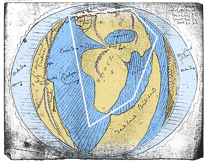
No. Our most important documents are the Professor’s maps of Middle-earth.
Some may not consider maps as evidences, but that is not right. Maps are shapes, and shapes can be one of the most important considerations for examining any subject. For example, the sciences of geography, archeology, mathematics, paleontology, and medicine are based on the comparison of shapes and conclusions drawn from those comparisons. When researchers see similarities between two shapes, they have the right to think that there may be a connection between the two shapes and to look for more similarities. If they find more evidences, they now have a professional duty to take the connection between the two shapes seriously and to seek a reason for those similarities. We have authentic documents from J. R. R. Tolkien, maps drawn by Professor Tolkien himself and his son Christopher. The mere absence of a statement about similarities between our earth and Middle-earth does not mean the absence of a document.
Therefore, Middle-earth maps are strong evidences for the validity of this theory. On the other hand, this point itself raises another question: Why is there so much insistence that we must find textual evidences about the existence of these similarities? Why are the maps of Middle-earth not deemed acceptable or satisfactory for some as a convincing reason? I think it’s because Tolkien is known primarily as a writer, not a cartographer, even though his art has received more well-deserved attention in recent years.
Tolkien was a linguist, the creator of several fictional languages, professor of Anglo-Saxon literature, a poet and the author of one of the greatest novels in history. Everything we know about him principally points to literature and poetry— in one word: Words! Every biography describes Tolkien as a writer, poet, and linguist, not a great cartographer or illustrator. The Lord of the Rings is a great literary work, not a classic comic strip, like the book series Tintin; Tolkien is a great writer, not a great writer-illustrator, as Herge. Is it therefore probable that this fact subconsciously led to the belief that verbal documents left by Tolkien were more acceptable than documents in the form of maps?
Like with other literary works, to understand Tolkien’s stories, we must first read the text of the book, and if we need more explanation—for example, if we want to understand the path the Fellowship took or the location of Fangorn Forest with regard to Isengard, we refer to the maps. The images and maps of Middle-earth serve as tools to help us better understand the story, but that does not mean they are of secondary importance to the text. Professor Tolkien himself tells us so:
I wisely started with a map, and made the story fit (generally with meticulous care for distances). The other way about lands one in confusions and impossibilities, and in any case it is weary work to compose a map from a story — as I fear you have found.” (Letter No.144 to Naomi Mitchison)
Contrary to what many readers assume, he began his magnum opus with maps. He showed the same precision in creating his maps as in creating the languages and historiography of his lands. The idea that his texts are more important than his pictures is not accurate at all. Citation of his maps as evidences, therefore, is perfectly reasonable. This point raises another issue: how is it possible that Tolkien created maps of his lands from real-world maps, but the connection between the two has not been made until recently?
The most important and well-known researchers of Tolkien and his works are specialists in literature, not illustration and cartography. Most of the researches on Tolkien’s world, especially in the fields of etymology and inspiration, are related to the world of his words and stories, not to the world of his pictures! It is natural that literary scholars, seeking to trace the origins of Tolkien’s world, first will search literary works, historical stories, and ancient and mythological texts related to them. If you give one of Tolkien’s created words to a linguist, he or she will eagerly find the root of the word in Old English, Welsh, Hebrew or Finnish. Tell the story of one of his wonderful characters to a mythologist, and you surely will hear about striking parallels to heroes or villains from Nordic or Greco-Roman mythology.
As a civil engineer, I have a corresponding interest in Tolkien’s maps; as a cartoonist, I pay close attention to his wonderful illustrations. I cannot ignore the similarities in map contours of Middle-earth and Google maps any more than an historian or theologian can ignore the ancient textual basis of the creation of the world by Iluvatar’s song. So when I talk about undeniable similarities, I do not mean deliberate or forced similarities. The map similarities exist, and I consider it my professional duty to make them clear to others.
Great works have already done on the maps of Middle-earth, such as Karen Wynn Fonstadt’s ‘Atlas of the Middle-earth’ and ‘The of Art of the Hobbit‘, ‘The Art of the Lord of the Rings’, and ‘J. R. R. Tolkien, Artist and Illustrator’‘ by Christina Scull and Wayne G. Hammond. Outstanding also is a collection of articles on the tor.com website, in which Alex Acks as a geologist shows the geological flaws of Middle-earth maps, flaws that my research will explain the reasons. None of the above, however, traced the origins of Middle-earth maps to our own world geography. And there was no reason for that because, as I explained in the first article of this series, I stumbled upon the striking similarities for the first time by accident.
The question naturally arises why Professor Tolkien, who—like some of his characters—loved riddles, would put these riddles only in his maps. The good news is these riddles are also present in Tolkien’s literature. In fact, Tolkien’s verbal riddles are a confirmation of his visual riddles! Let’s start with a name:
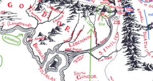
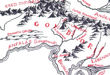
Gondor
The Tolkien Estate Limited – used with kind permission©
Gondor is the southern portion of Middle-earth settled by the exiles from the ancient island kingdom of Númenor, led by Elendil and his famous sons Isildur and Anárion. You will soon see that the word Gondor is related to the areas corresponding with Gondor in our world: those adjacent to the Himalayas and the countries of India, Pakistan, and Afghanistan!
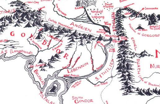
Professor Tolkien tells us that Gondor is a word in the Sindarin language consisting of gond, meaning stone, and dor, meaning land: land of stone. This new kingdom came to be characterized by magnificent cities built with native stones. Now remember Gondor’s position on the map of Middle-earth: west of Mordor and the Ephel Duath Mountains, and let’s take a closer look at similar areas in our world:.
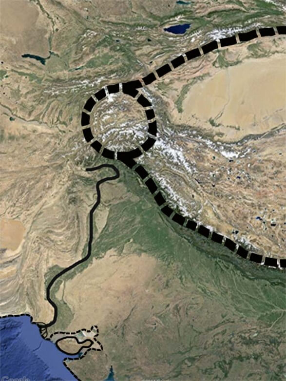
Map by Google Maps
Searching the history and geography of the region we find that for centuries in the western Himalayas, exactly in areas similar to Gondor’s position in the Middle-earth, a kingdom ruled with a culture as great and glorious as the kingdom of Gondor: a kingdom called Gandhara!
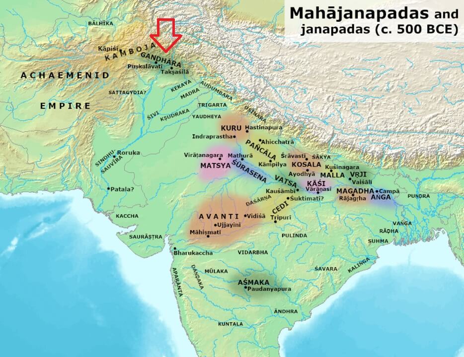
Wikipedia, Kingdoms and cities of ancient India, with Gandhara located in the northwest of the Indian subcontinent, during the time of the Buddha (c.500BC)
This map shows Gandhara. This might look small compared to Gondor on Tolkien’s maps, so let’s look at another map to gain a fuller perspective:
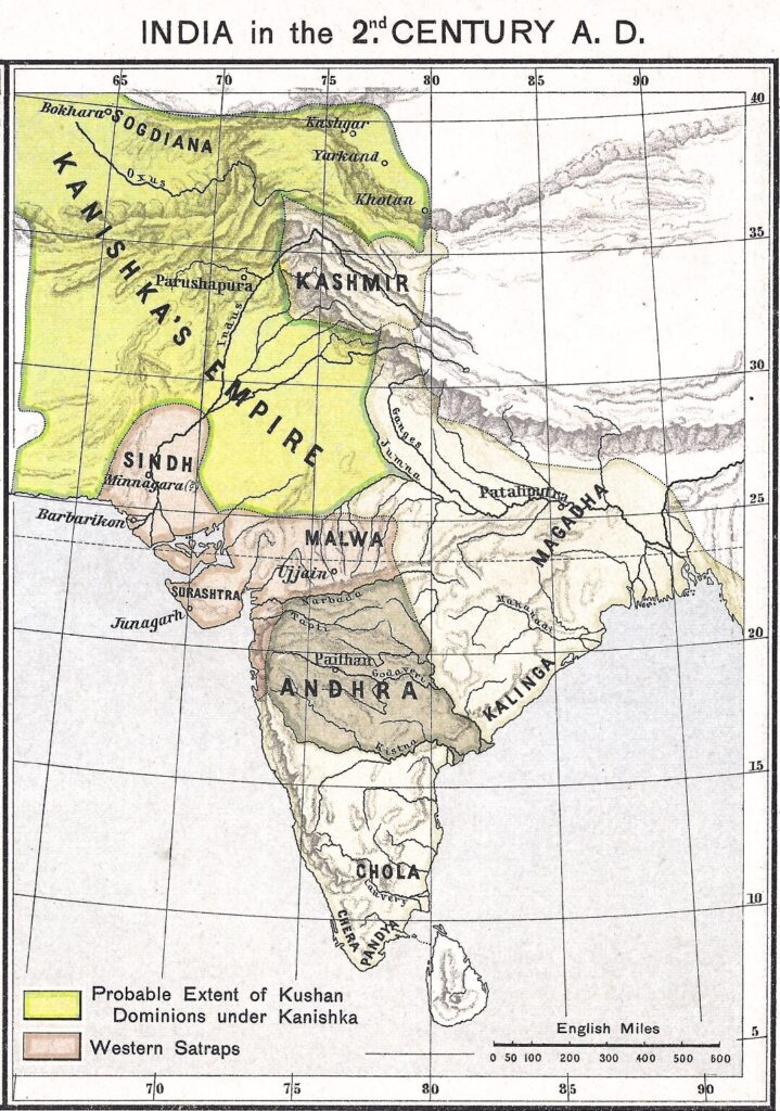
Wikipedia, Map of Gandhara in age of Kushan Empires
Now that’s more like Gondor! It represents Gandhara at its height during the Kushan Empire.
Gandhara is an ancient kingdom that had ruled this region of the world for thousands of years. If you have never heard of it, it is probably because of its geographical location among the three major neighboring countries: India, China, and Iran. Although Gandhara was not a small country, being among the three great powers in the region influenced it culturally, politically, and militarily. The name Gandhara appears in maps today in the form of the city of Kandahar in Afghanistan. But that is not the only thing left of Gandhara, for the images you see are artifacts of this ancient civilization.
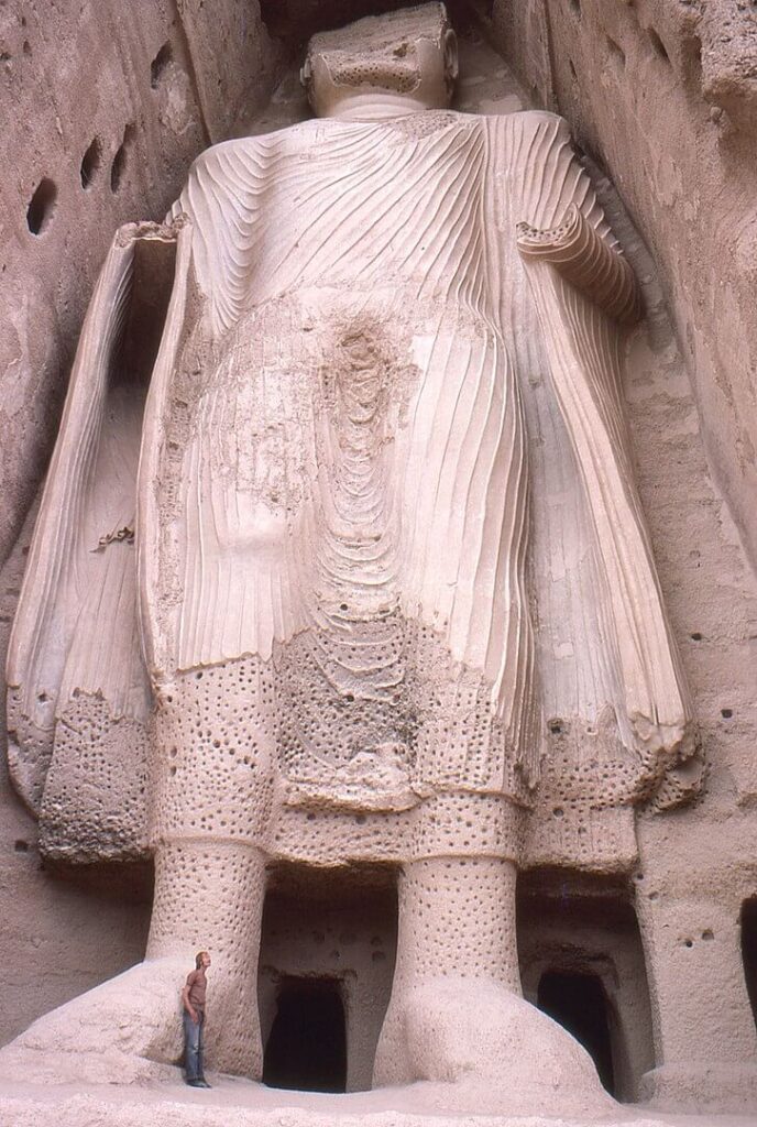
Wikipedia, Smaller Bamyan Buddha from base, Afghanistan
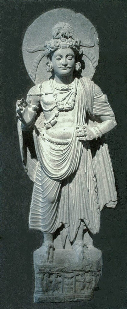
Wikipedia, Standing Bodhisattva (1st – 2nd century)
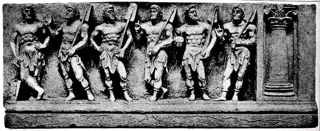
Wikipedia, Marine deities Gandhara
Doing something like this with Gondor is not strange at all for someone as brilliant as Tolkien, for he did the same thing before with Atalantë, the name given to the island of Númenor after its sinking. It means The Downfallen in Quenya. Let us briefly review the downfall of Númenor: its island inhabitants tried to invade the land of the gods and the gods drowned their island as just punishment. If you tell this story to any archaeologist, mythologist, or fantasy lover, they will have no doubt that you are talking about the lost island of Atlantis! According to Plato, Atlantis was an island nation of unknown location filled with proud people of an advanced civilization who angered the Greek god Zeus by attacking other lands. He punished them by drowning their island in a storm. The resemblance between downfall of Númenor and Atlantis is indisputable. But Professor Tolkien’s answer to the often-asked question whether the name of his island, Atalantë, had anything to do with Atlantis is:
A happy accident!
Tolkien derived Atalantë from the root of the Quenya verb talat, meaning to fall down. Some may disagree with me, but I think this is one of the times Tolkien seems to be joking with us! It would be no surprise for him to do something fun like this by turning Gandhara into Gondor. This is not at all strange or impossible for someone who has enough initiative to start a story with a map.
Let’s go on to another example: Anduin is made up of And meaning long or great and Duin meaning river, which together means The Great River. Here Tolkien seems to have used the initial letters of the Indus River (Ind) to make And, only changing the letter I to A. Most of the Indus River is in Pakistan, but India was named after this river. It means the land adjacent to the Indus River. So if my assumption is correct, then the word Anduin will probably have a similar meaning to Ind-Duin or The Indian River.
I think now is probably the right time to ask an important question, a question that has probably occupied the minds of many: Why India? Why Tibet and the Himalayas? Why Afghanistan and Pakistan? And why the East? Why would Tolkien be inspired by such places for his stories of Middle-earth?
An objective source of inspiration
Professor Tolkien clearly spent his life focusing on European culture, but its geography did not suit all his stories. In that case it would be no surprise for this learned man to consider other parts of the globe as a basis for the maps he made to further his tales. His borrowing from Eastern maps does not therefore mean the East was his source of inspiration. Let me explain with an example.
About the same time Tolkien was writing LOTR Hergé was working on Tintin, a series of stories that take place in Belgium, Britain, the United States, India, China, Egypt, the Middle East, and South America. Does that indicate Hergé had bittersweet memories in South America or that he taught Hindi? Of course not. Like Tolkien, he was a creative and knowledgeable writer who placed his characters wherever he saw fit. When creating the lands of Middle-earth, Tolkien was completely free to think of wherever he liked and to create whatever he liked because Tolkien the fantasy author was not functioning as Tolkien the Oxford professor who had to teach a certain course. He was not writing an academic book on European mythology; he was writing a fantasy story. Therefore, it is possible that European and other themes Tolkien was interested in may or may not be found in his books. To discern his sources of inspirations we need to rely on similarities, signs, and documents, not Tolkien’s psychology or personality because we can never guess what really went through Tolkien’s mind when he wrote his stories.
We should not expect to find a statement from Tolkien that the Himalayas were his source of inspiration for the creation of Mordor because the Himalayas and other lands on real-world maps do not represent Tolkien’s sources of inspiration. They are simply places he noticed that helped him make his Middle-earth maps more believable, which was very important to him. As he explains in his essay On Fairy-Stories, he believed the author of such stories should seek to serve as a sub creator of realistic secondary worlds.
We do not need to delve into Tolkien’s psyche or personal experiences, but instead consider the unique geographical features of the Himalayan mountains and Indus River valley of our world that would well convey his story in LOTR. This is an objective approach to understanding why the Professor drew his maps the way he did.
Irresponsible re-symbolization
This objective approach I’m proposing for interpreting Professor Tolkien’s maps is much better than fanciful ideas of this beloved author’s inspirations based on perceptions of his psychology and beliefs. Such ideas tend to tell more about the psychology and beliefs of the person doing the perceiving! For example, it has been speculated that the story of The Lord of the Rings is a symbol of World War I and the British war against Germany and the Ottomans in the East because of Tolkien’s difficult experiences as an officer serving in that war. The 2019 Tolkien biopic, for instance, placed us inside young Tolkien’s mind, transforming horrific images of trench warfare into monster-shaped creatures. But would the Professor himself want us to assume Sauron, Smaug and the Ringwraiths are subconscious perceptions of fire, chemical weapons, and otherwise hellish conditions of the Somme battlefields? He himself wrote in the forward to the second edition of LOTR,
An author cannot of course remain wholly unaffected by his experience, but the ways in which a story-germ uses the soil of experience are extremely complex, and attempts to define the process are at best guesses from evidence that is inadequate and amibigious. It is also false, though naturally attractive … to suppose that the movements of thought or the events of times common to both {author and interpreter} were necessarily the most powerful influences.
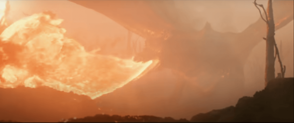
Young Tolkien sees a flamethrower as a dragon. — ‘Tolkien (2019)’, Twentieth Century Fox
Let me give you another strange LOTR interpretation, this time from my own country, Iran. Now we have many devoted admirers of Professor Tolkien’s works there, but some readers are jaded by Iran’s long history of pessimism towards the West. That came from British quasi-colonial behavior in Iran and Iran’s not-so-friendly relations with the United States over the past four decades. “It’s an English job!” is a famous saying of a popular fictional character in Iran who assumes an English conspiracy is behind the scenes of everything. That has led some Iranians to assume LOTR is an insult to the peoples of the Middle East and a continuation of European colonialism!
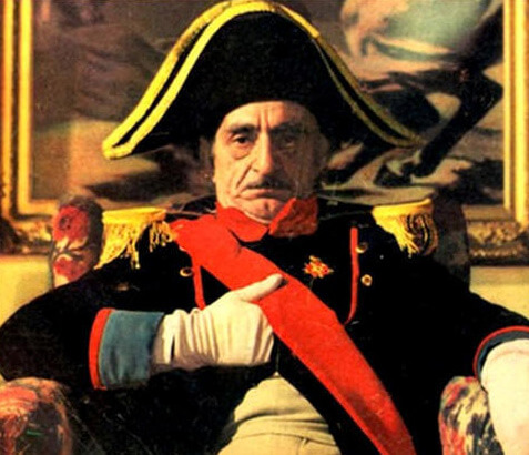
Uncle Napoleon, the fictional character of the popular book and TV series of the same name. He sees himself as a hero against the British Army and has become a lasting symbol of people who see conspiracy theories behind everything
Some in Iran actually believe that the East in Tolkien’s stories is a symbol of the Middle East, for they assume that the dark-skinned Haradrims are a symbol of Muslims. Therefore, they feel insulted. And who is the author of the book? An Englishman. These irresponsible symbolists would say that proves it’s an English job!
Here is another example of irresponsible symbolism: I have been carefully studying the comments of Tolkien fans in virtual groups for a long time to understand their views on the meaning and concept that the stories and characters create for them. What I realized since the beginning of the war in Syria and ISIS terrorist attacks in Europe, the belief that LOTR symbolizes some kind of battle between the Christian and Islamic worlds has become popular among some of Tolkien Christian readers too. Why are there such strange and contradictory ideas about hidden meanings in The Lord of the Rings? Some readers of Tolkien’s works irresponsibly allow themselves to put their own perceptions in the place of Tolkien himself.
Tolkien has recently been accused of even being a racist! That is an inaccurate and terrible accusation for anyone to make of this good man. I believe this kind of accusation comes from irresponsible re-symbolization, which is redefining and symbolizing a story in the way we want, and then making an arbitrary interpretation of it. However, based on what Tolkien said and what the similarities between the maps show, Tolkien’s stories do not seem to be very symbolic. The similarities we see in the maps are more of a riddle than a symbol of the war of civilizations! Tolkien clearly shows the locations of his stories through maps, so Mordor is neither the Ottoman Empire, nor the Third Reich, nor the Socialist Soviet Union, nor the Islamic Middle East! Mordor’s map is taken from the Himalayas in Asia and has no special political or colonial meaning behind it. The only apparent reason for using it is this area is a unique circular mountainous area quite suitable for difficult access to Mount Doom, making the poor Hobbits work harder.
I hope that with the new information we have about the maps, irresponsible symbolism about Tolkien’s works will be reduced, but on the other hand, I am worried now that some people will link Mordor’s dispute with Gondor to recent tensions between India and China!