 آردا، دنیای تالکین سایت طرفداران تالکین در ایران. جایی برای گفتگو در مورد ارباب حلقه ها و دیگر آثار تالکین به زبان فارسی
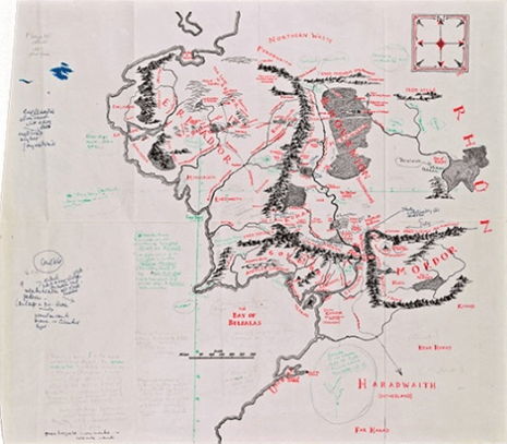
The Tolkien Estate Limited – used with kind permission©
این مقاله به فارسی نیز وجود دارد. در اینجا آن را مطالعه نمایید.
Written by Mohammad Reza Kamali-
Edited by Allacin Morimizu-
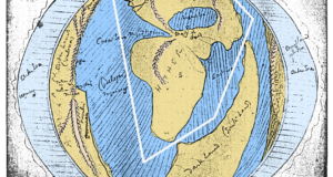
In 2015 the world was thrilled to learn that a map of Middle-earth with notes by Professor J. R. R. Tolkien for illustrator Pauline Baynes was discovered in a copy of The Lord of the Rings. Tolkien wrote comments using green ink to guide Baynes, who back in 1969 was working on a color map of Middle-earth. Tolkien included information about places that inspired him for Hobbiton, Minas Tirith, and other places. This find was intensely interesting to me since I have spent several years researching real places and lands that inspired the professor to create his beloved world. But nothing unexpected in his comments on the newly found map appear –at first glance– since they confirm previous information we have in one of his own letters:
The action of the story takes place in the North-west of ‘Middle-earth’, equivalent in latitude to the coastlands of Europe and the north shores of the Mediterranean…. If Hobbiton and Rivendell are taken (as intended) to be at about the latitude of Oxford, then Minas Tirith, 600 miles south, is at about the latitude of Florence. The Mouths of Anduin and the ancient city of Pelargir are at about the latitude of ancient Troy (Letters, no. 294 from March 1968).
This is Tolkien’s most famous quote about Middle-earth as it relates to our earth. Happily for me at this point, a friend suggested I take a closer look at Tolkien’s notes. I did and realized this time that Tolkien introduced Ravenna, another Italian city, as Minas Tirith–not Florence. Let’s read what he wrote in the annotated map:
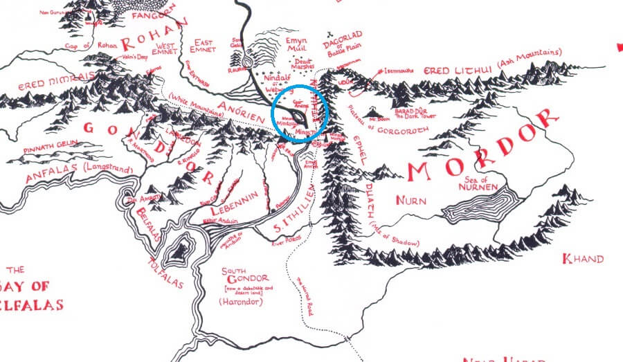
Hobbiton is assumed to be approx at latitude of Oxford. The green vertical line is marked at distances of 100 miles (2cms to map scale). So you can roughly judge the climate and Fauna/Flora etc. Minas Tirith is about a latitude of Ravenna (but is 900 miles east of Hobbiton, more near Belgrade). Bottom of the map (1400 miles) is about a lattitude of Jerusalem. Umbar & City of Corsairs –about that of Cypres. green horizontal is also marked in 100 mile intervals.
Tolkien’s famous quote was from a letter we know was written in March 1968, but the newly found notes were written in 1969. So what happened here? Did Tolkien forget about Florence and write Ravenna instead? Since he was inspired to write of a city as great as Minas Tirith, how is it possible that he writes two different names at different times about his inspiration? It becomes more interesting when he talks about Belgrade. So which one is Minas Tirith: Florence, Ravenna, or Belgrade? Did Professor Tolkien really say anywhere in his letters or comments that Florence was his “inspiration” for Minas Tirith? Let’s go back to the quote.
If Hobbiton and Rivendell are taken (as intended) to be at about the latitude of Oxford, then Minas Tirith, 600 miles south, is at about the latitude of Florence.
Does that mean inspiration to you? The answer was always here:
The action of the story takes place in the North-west of ‘Middle-earth’, equivalent in latitude to the coastlands of Europe and the north shores of the Mediterranean.
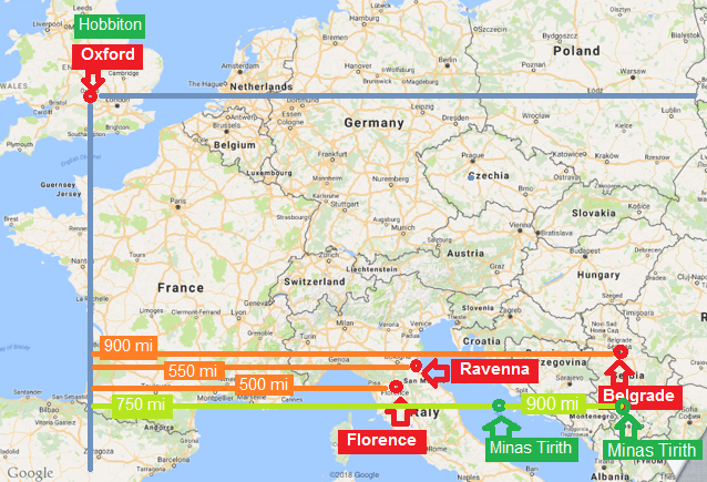
I think Professor Tolkien is talking about distances, not inspirations! If you compare the map of northwest Middle-earth with a map of Europe, you will find that they are really equal in latitude, exactly as Tolkien said. He clearly means Minas Tirith is the same distance from Hobbiton as Oxford is from Florence! To test the idea we need to overlay maps of Middle-earth and Europe. We add the situation of Hobbiton and Minas Tirith to a European map considering Oxford as Hobbiton to get a mixed Middle-earth and European map:
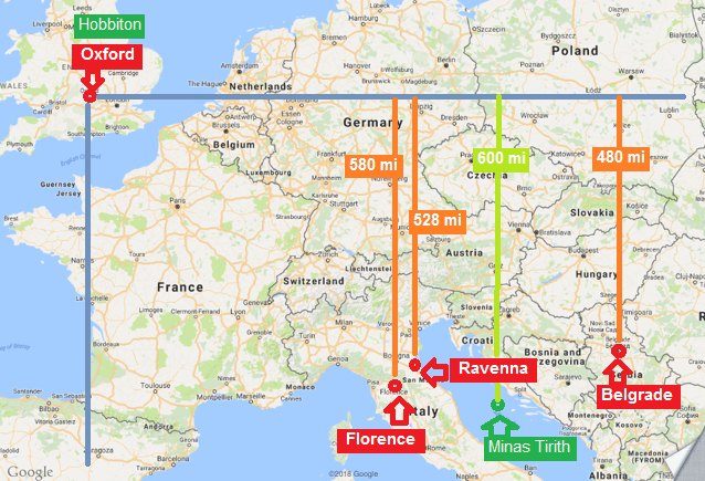
Map by Google Maps
Both vertical distances of Florence and Minas Tirith to Oxford are about 600 miles, as Tolkien said and as you can see in the map. So what about Ravenna? Why did he change the target city? Look at the map. Ravenna is about the same vertical distance from Oxford that Florence is, but is a better choice because it is closer to the Minas Tirith location. This clearly shows that when Tolkien wrote down Ravenna instead of Florence, he didn’t forget what he said about Florence one year before. He wanted to correct what he said previously and guide Pauline Baynes to draw her map more accurately. What about Belgrade?
Minas Tirith is about a latitude of Ravenna (but is 900 miles east of Hobbiton, more near Belgrade).
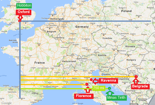
When pointing to Belgrade, Tolkien explains that the horizontal distance between Hobbiton and Minas Tirith is more than horizontal distance between Oxford and Ravenna:
Map by Google Maps
The horizontal distance from Hobbiton to Minas Tirith is about 750 miles according to Tolkien’s map and I drew it with the same distance as shown in the Middle-earth map, but Tolkien says in the comment that it is 900 miles. This helps us realize that maybe the map was not accurate enough, and Tolkien wanted to help Baynes to figure out the real location of Minas Tirith by pointing to Ravenna and Belgrade:
Oxford to Florence is about 500 miles.
Oxford to Ravenna, which is a better choice, is 550 miles.
Both have about the same vertical distance of 600 miles, but are not close to the horizontal distance of 900 miles, so Tolkien points to Belgrade, with a horizontal distance of about 900 miles. You can see in the map below that Minas Tirith, 900 miles distant from Hobbiton, is close to Belgrade. (I show two Minas Tiriths with 750 and 900 miles distant according to map and comment.)
Map by Google Maps
Notice Tolkien actually says, ”More near Belgrade”–not Belgrade itself. That “more near“ explains everything: he meant distances, not inspirations! Professor Tolkien was helping us understand the approximate size of Middle-earth by guiding Pauline Baynes to draw his map more accurately.
And let’s be honest: Florence and Ravenna and Belgrade are amazing places, but they don’t look like the Minas Tirith that we know! The only thing in common between those three beautiful cities in this analysis is that they have almost the same vertical distance to Oxford.
So if Europe itself was not Tolkien’s inspiration for Middle-earth and we read his quotes wrongly, what was? During my research on Middle-earth with the help of maps, I found that maybe there are real lands could have inspired Professor Tolkien, and some of them are not in Europe. The discovery of this annotated map was like a miracle to me because when I myself discovered real maps with unbelievable similarities to Middle-earth and tried to share that information, most of the times I was answered: “Very clever, but that must be an accident, since Tolkien himself wrote that Europe was his inspiration, not the lands that you think.” Now we know otherwise!
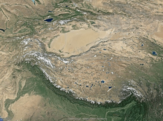
It all started almost by accident when I saw this picture:
Map by Google Maps
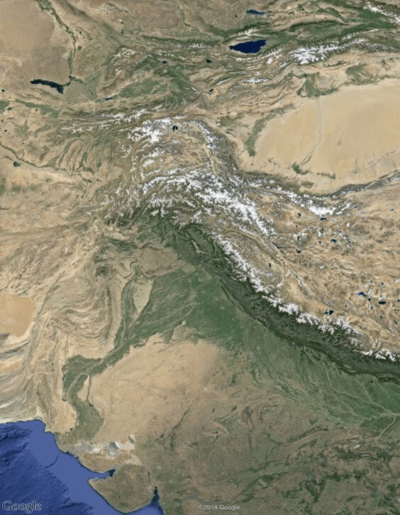
Around 2012 I was staring at the picture above of some mountains in Google Maps, and kept thinking that it really looks familiar, like a map I’d seen before—this map:
The Tolkien Estate Limited – used with kind permission©
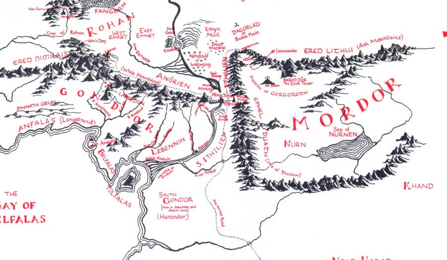
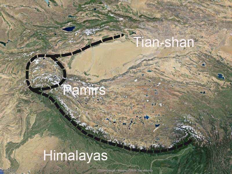
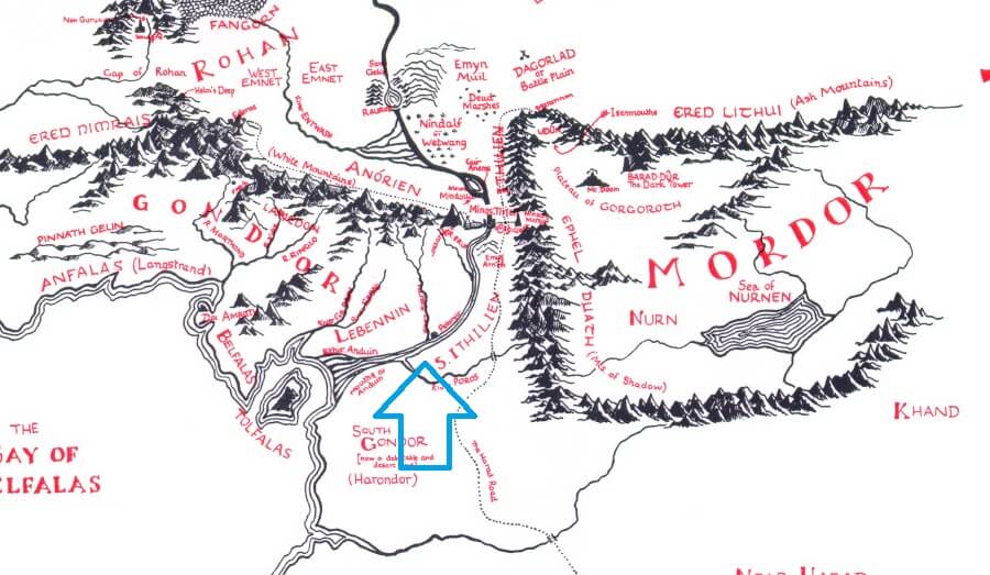
This, of course, is Mordor, the land of Sauron and dark powers of Middle-earth, where Frodo and Sam destroy the One Ring. The first picture is a ring of mountains in the heart of Asia: the Himalayas, Pamirs, and Tian-shan mountains. Notice the similarities.
Map by Google Maps
The Encircled Mountains
At first I thought this was an accident, but then I noticed Professor Tolkien named Mordor’s mountains in the same way the ancient Asians named their mountains. In our world, both the west and south mountains have one name: Himalayas. In Mordor, the west and south mountains have one name: Ephel Duath. Look at Mordor again. We might expect Tolkien to choose one name for the south range and one for the west, but he didn’t. Let’s now look north. In the northwest corner the circle-shaped Pamirs are the same shape and in exactly the same corner as the Udûn of Mordor. Udûn is where Frodo and Sam originally tried getting into Mordor through the Black Gate, so that circle-shaped mountain was useful for making Mordor harder to get into. But why it must be located exactly at northwest corner? Here’s a bigger question: Why did Tolkien give Mordor a U shape? Why not a circle? A circle would be so much safer than a U!
Studying these pictures and thinking about these questions as a civil engineer who always works with maps, I began to realize that my favorite writer may have been inspired by Asia as he fashioned his Middle-earth. Then I started wondering if Middle-earth is rooted in our earth. To help find our answer, let’s look at something as big and as important as Mordor: Anduin, the most famous river of Middle-earth.
The Great River
Anduin, the great river, is the location of some of the saddest and most glorious stories of Middle-earth:
- Isildur jumps into the Anduin, hoping to flee an ambush, but is killed by Orc arrows.
- The One Ring is then lost in its waters and Sméagol later comes to possess it after killing Déagol.
- The Fellowship continues their journey on the Great River after leaving Lothlórien. Boromir is killed in this part of the journey.
- And at last, the Lord Aragorn and his mighty company ride the Black Ships up the Anduin, rescuing besieged Minas Tirith in the Battle of the Pelennor Fields.
© The Tolkien Estate Limited – used with kind permission.
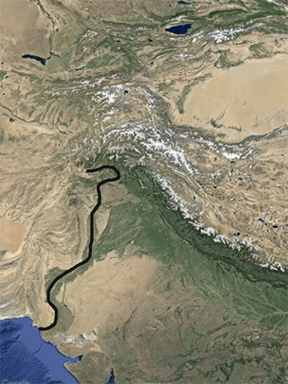
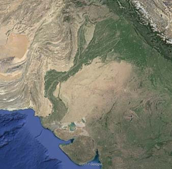
Anduin River is much longer than what we see here, for the map above is only the southern part between Gondor and Mordor. Look at the river’s shape: it moves north to south near Mordor but changes its way to southwest before it reaches the sea. Let’s now look at the west side of the Himalayas to see if a river is there:
Map by Google Maps
Notice the green S shape to the west? Well, that’s a river!
The green parts are farms and fertile lands around it. And this is no ordinary river since it is as important and famous as the Anduin: the Indus River, from which the country of India took its name. Indus is one of the world’s longest rivers. Notice its shape apart from its green lands:
Map by Google Maps
Look again at the direction of the Anduin and Indus Rivers. Both are on the same side of the same shape mountains, and move southwest before they reach the sea.
The River Island
What about Cair Andros Island? Never heard of it? It’s not as famous as the Anduin because in the story nothing much happens there. But it’s on Tolkien’s map a few miles above Osgiliath, where the river has a vertical shape:
© The Tolkien Estate Limited – used with kind permission.
Is there any island in the same part of the Indus River? Well, this time if you look at Google Maps you can’t find any island there. I mean you can’t see it now because once there was a big island there! And how is it possible for a big island to disappear? It didn’t: the island is part of a huge dam now! See Wikipedia:
Tarbela Dam on the Indus River in Pakistan is the largest earth-filled dam in the world and second largest by structural volume. It is located in Haripur District…. The project is located at a narrow spot in the Indus River valley, at Tarbelain Haripur, shortly located at the point from where the District Swabi then starts. Here the river formerly split around a large island close to the left bank. The main dam wall, built of earth and rock fill, stretches 2,743 meters (8,999 feet) from the island to river right, standing 148 metres (486 feet) high. A pair of concrete auxiliary dams spans the river from the island to river left.
Here’s the location of Tarbela Dam:
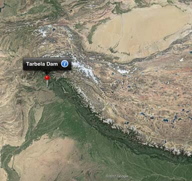
Map by Google Maps
We have to zoom in and with our information about the dam, we can distinguish the island. This is our lost island in Google Maps.
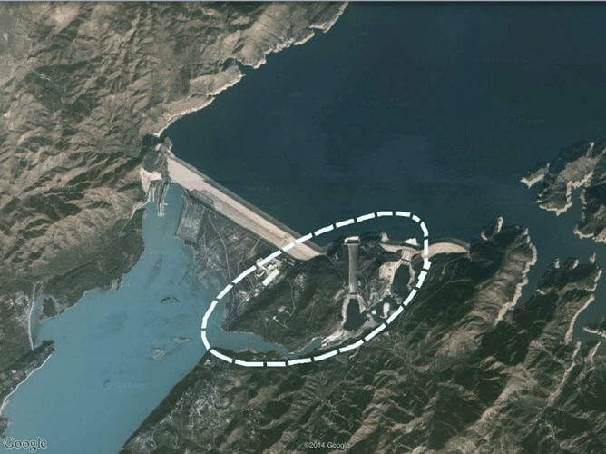
Map by Google Maps
Here is another view of the island.
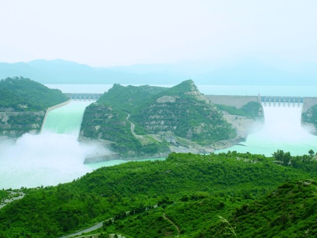
Photo: WAPDA, Pakistan Water & Power Development Authority.
Because of the dam, the shape of the island is now changed. Surely some part of it is under water, and some parts maybe changed because of the construction. Before the dam was built, there was no lake there. The river had the same width as it has in upper places and the island looked bigger; it probably had the same shape that Tolkien drew in his map. Unfortunately, I didn’t find the island’s name, if it had one, or any maps that show it, but I did learn this dam was built during 1968-1976. When Tolkien was writing The Lord of the Rings and drew the maps from 1937-1949, there was still a big island there!
The Intermittent Island
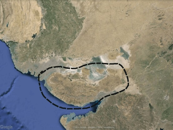
We found one lost island, so let’s see if we can find another one where nothing much happened: Tolfalas Island, located where the Anduin reaches the sea.
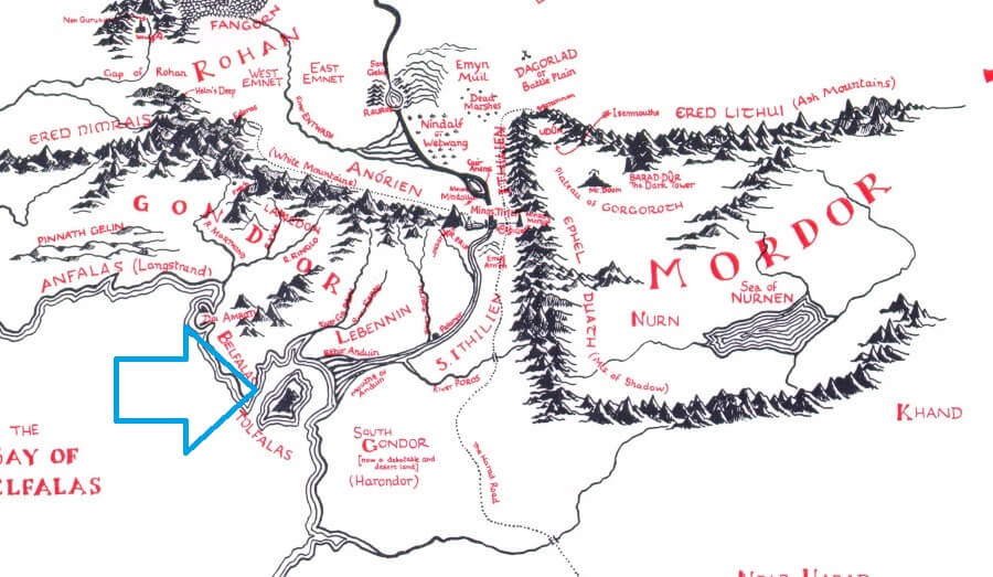
© The Tolkien Estate Limited – used with kind permission.
Let’s now look at Google Maps.
Map by Google Maps
No island visible from this perspective so we will zoom in to be sure.
Map by Google Maps
We need to know more about this place. This area is Kutch, a district of Gujarat province, India. This area in fact is an island! Wikipedia again informs us:
Kutch is a district of Gujarat state in western India…. Kutch literally means“something which intermittently becomes wet and dry”; a large part of this district is known as Rann of Kutch, which is shallow wetland submerged in water during the rainy season and becomes dry during other seasons…. Kutch district is surrounded by the Gulf of Kutch and the Arabian Sea in the south and west, while the northern and eastern parts are surrounded by the Great and Little Rann (seasonal wetlands) of Kutch.
That means Kutch is actually an island in rainy seasons! Here is another picture from Google Maps during such a time:
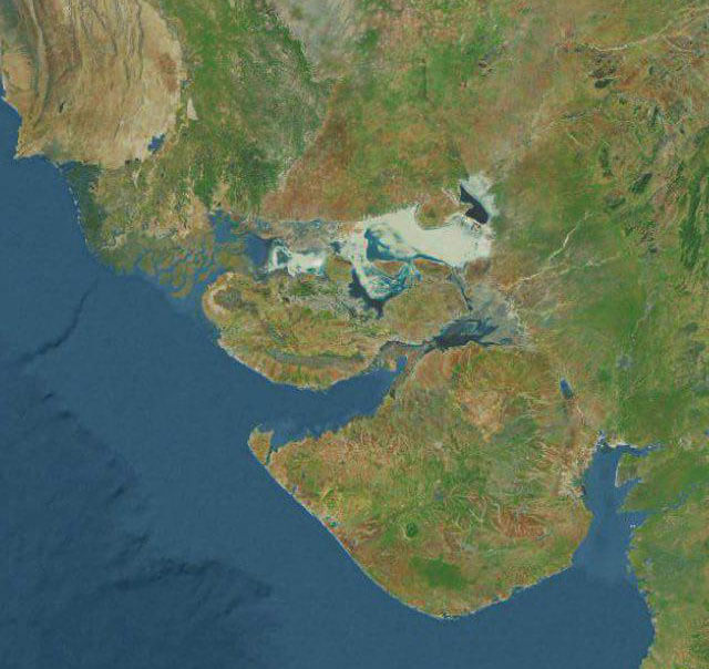
Map by Google Maps
One question, however: would Tolkien know about this in the 1940s? He never travelled to India and obviously didn’t have Google Maps. We need to remember that he was British, and in those times the countries we know today as India and Pakistan were known as the British Indian Empire. This is a standard map from 1909 that Professor Tolkien would have had access to:
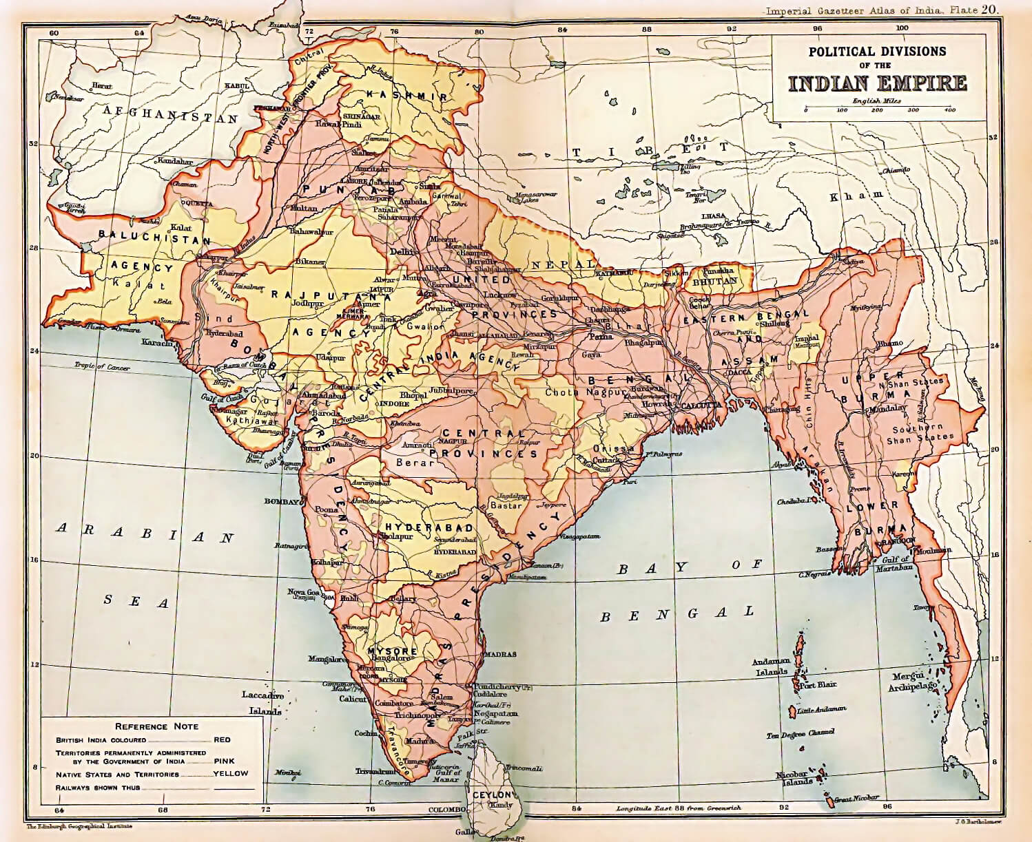
Map by Edinburgh Geographical Institute; J. G. Bartholomew and Sons. [Public domain], via Wikimedia Commons
When we zoom into Kutch on this map, we see it is drawn as an island!
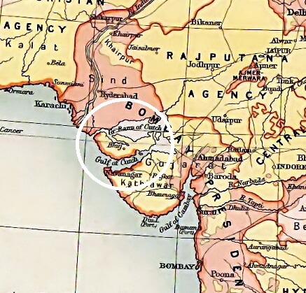
Map by Edinburgh Geographical Institute; J. G. Bartholomew and Sons. [Public domain], via Wikimedia Commons
So what do all these geographical facts mean? As I said, this article is part of more extensive research I did about Middle-earth maps. It shows that most of the lands we see in Middle-earth maps actually were taken from our world. Furthermore, I found that this is true not just about mountains, rivers, and islands but also many of the cities, buildings, stories, and even characters of Tolkien’s beloved books. And one other thing, I’m not sure we should call them Tolkien’s inspirations. I think Professor Tolkien preferred to think of them as riddles. That’s why you can’t see them easily because they have been hidden by a clever professor who enjoys riddles!
Part 2: The Tale of the annotated map and Tolkien’s hidden riddles
Part 3: The Tale of the annotated map and Tolkien’s hidden riddles

۱ دیدگاه
بازخورد: Pixel Scroll 5/23/21 Looking Up Out Of An Inkwell | File 770